Datasets describe the data model of a project. Each dataset represents a database table. They also define the constraints and links between all other datasets in a project.
...
| Info | ||
|---|---|---|
| ||
Numeric Numeric
|
vt.ref
A reference of a dataset vt type.
...
| Key | Type | Optionality | Description | Constraints | ||||||||
|---|---|---|---|---|---|---|---|---|---|---|---|---|
min | integer |
| minimal available zoom level | 2 .. 18 | ||||||||
| integer |
| maximal available zoom level | 2 .. 18 | ||||||||
optimal | integer |
| optimal zoom level | 2 .. 18 | ||||||||
visibleFrom | integer |
| zoom level from which the dataset's feature will be visible
| 2 .. 18 |
h3Grid.ref
A reference of a dataset h3Grid type.
| Key | Type | Optionality | Description | Constraints | ||||||
|---|---|---|---|---|---|---|---|---|---|---|
type | string |
| type identifier, always h3Grid | [ | ||||||
resolution | string |
| resolution of the grid | 2 .. 10 | ||||||
zoom | object |
| map zoom object |
h3Grid.ref.zoom
Set desired zoom levels for the h3Grid datasets.
| Key | Type | Optionality | Description | Constraints | ||||||
|---|---|---|---|---|---|---|---|---|---|---|
min | integer |
| minimal available zoom level | 2 .. 18 | ||||||
| integer |
| maximal available zoom level | 2 .. 18 | ||||||
optimal | integer |
| optimal zoom level | 2 .. 18 |
Visual representation
...
Native datasets in this project are baskets, shops and clients. The other datasets were imported from different data dimensions. The datasets in orange were imported from the can-dim-dates dimension. Brown datasets are from a UK administrative units dimension. The dataset demography_postcode comes from a UK demography dimension. The h3Grid datasets are pink.
...
For geometryPoint and geometryPolygon datasets, a tooltip is shown on hover. The content is defined in dataset.properties.
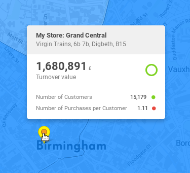
"My Store: Grand Central" is the featureTitle.
...