Datasets describe the data model of a project. Each dataset represents a database table. They also define the constraints and links between all other datasets in a project.
...
| Info |
|---|
In |
...
| Code Block | ||||
|---|---|---|---|---|
| ||||
{
    "name": "district",
    "type": "dataset",
    "title": "Districts",
    "origin": "https://secure.clevermaps.io/rest/projects/mxl3pmyqc7kz04hl/md/datasets?name=district",
    "properties": {
        "featureTitle": {
            "type": "property",
            "value": "districtname"
        },
        "featureSubtitle": {
            "type": "property",
            "value": "upper_admin_name"
        }
    },
    "ref": {
        "type": "dwh",
        "subtype": "geometryPolygon",
        "geometry": "districtgeojson",
        "visualizations": [
            {
                "type": "areas"
            }
        ],
        "table": "district_dwh",
        "primaryKey": "districtcode",
        "categorizable": false,
        "fullTextIndex": true,
        "properties": [
            {
                "filterable": false,
                "name": "districtcode",
                "title": "districtcode",
                "column": "districtcode",
                "type": "string"
            },
            {
                "filterable": true,
                "name": "districtname",
                "title": "districtname",
                "column": "districtname",
                "type": "string"
            },
            {
                "filterable": false,
                "name": "y_min",
                "title": "y_min",
                "column": "y_min",
                "type": "decimal(19,16)"
            },
            {
                "filterable": false,
                "name": "y_max",
                "title": "y_max",
                "column": "y_max",
                "type": "decimal(19,16)"
            },
            {
                "filterable": false,
                "name": "x_min",
                "title": "x_min",
                "column": "x_min",
                "type": "decimal(19,16)"
            },
            {
                "filterable": false,
                "name": "x_max",
                "title": "x_max",
                "column": "x_max",
                "type": "decimal(19,16)"
            },
            {
                "filterable": true,
                "name": "upper_admin_name",
                "title": "upper_admin_name",
                "column": "upper_admin_name",
                "type": "string"
            }
        ]
    },
    "dataSources": [
        {
            "licenceHolder": "Office for National Statistics",
            "licenceHolderUrl": "https://www.ons.gov.uk/",
            "licenceUrl": "http://www.nationalarchives.gov.uk/doc/open-government-licence/version/3/"
        }
    ]
}
|
...
Native datasets in this project are baskets, shops and clients. The other datasets were imported from different data dimensions. The datasets in orange were imported from the can-dim-dates dimension. Brown datasets are from a UK administrative units dimension. The dataset demography_postcode comes from a UK demography dimension. The h3Grid datasets are pink.
...
For geometryPoint and geometryPolygon datasets, a tooltip is shown on hover. The content is defined in dataset.properties.
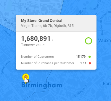
"My Store: Grand Central" is the featureTitle.
...