Datasets describe the data model of a project. Each dataset represents a database table. They also define the constraints and links between all other datasets in a project.
...
| Key | Type | Optionality | Description | Constraints | ||||||||
|---|---|---|---|---|---|---|---|---|---|---|---|---|
type | string |
| type identifier, always dwh | [dwh] | ||||||||
| string |
|
| [basic, geometryPoint, geometryPolygon, geometryLine, date] | ||||||||
geometry | string |
| geometry reference to a vector tile dataset required only for | {datasetName} | ||||||||
h3Geometries | array |
| array of references to enables the grid visualization | |||||||||
visualizations | array |
| array of objects specifying the allowed visualizations of the dataset required only for | |||||||||
zoom | object |
| map zoom object | |||||||||
table | string |
| name of the actual it's derived from the name of the dataset, and _X postfix is added for each full load, where X is the number of the load | (a-z0-9_-) | ||||||||
primaryKey | string |
| primary key of the table - must be one of the dataset properties should be unique | {datasetProperty} | ||||||||
categorizable | boolean |
| indicates if the dataset is capable of being categorized in the Filters tool ( default = should be | [true, false] | ||||||||
fullTextIndex | string |
| indicates if the dataset's data will be indexed for full text search in Search tool ( default = | [true, false] | ||||||||
properties | array |
| array of dataset property order must be identical to the order of the data columns size must be at least 1 |
...
| Key | Type | Optionality | Description | Constraints | ||||||||
|---|---|---|---|---|---|---|---|---|---|---|---|---|
name | string |
| name of the column as it will be referenced in other objects | (a-z0-9_-) | ||||||||
| string |
| human-readable title of the column | (*) | ||||||||
column | string |
| name of the column as it is in the database table | (a-z0-9_-) | ||||||||
type | string |
| column data type detailed description in the table below | [integer, bigint, decimal, string, boolean, date, latitude, longitude, h3_grid] | ||||||||
foreignKey | string |
| name of the dataset, whose if this key is mentioned, | (a-z0-9_-) | ||||||||
filterable | boolean |
| indicates whether it's possible for this property to be added to a filter default = | [true, false] | ||||||||
description | string |
| description of the property which appears in Filters ( | (*) | ||||||||
displayOptions | object |
| options that specify how the property will be displayed |
...
Native datasets in this project are baskets, shops and clients. The other datasets were imported from different data dimensions. The datasets in orange were imported from the can-dim-dates dimension. Brown datasets are from a UK administrative units dimension. The dataset demography_postcode comes from a UK demography dimension. The h3Grid datasets are pink.
...
For geometryPoint and geometryPolygon datasets, a tooltip is shown on hover. The content is defined in dataset.properties.
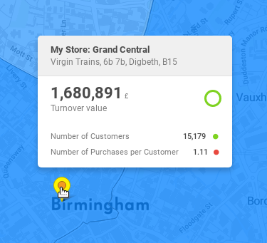
"My Store: Grand Central" is the featureTitle.
...