Data dimensions are prepared projects that contain specific data (e.g. administrative units or demography). They can be imported into other projects and combined with their data.
List of data dimensions projects:
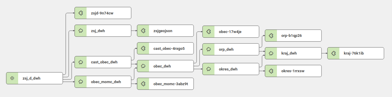
can-dim-adm-units-cz-en
Administrative units of the Czech Republic
Administrative units hierarchy of the Czech Republic.
- Project ID: q1zdp9d0ao78rdv5
- Link: https://secure.clevermaps.io/#/q1zdp9d0ao78rdv5/project
Every hierarchy unit has its own table:
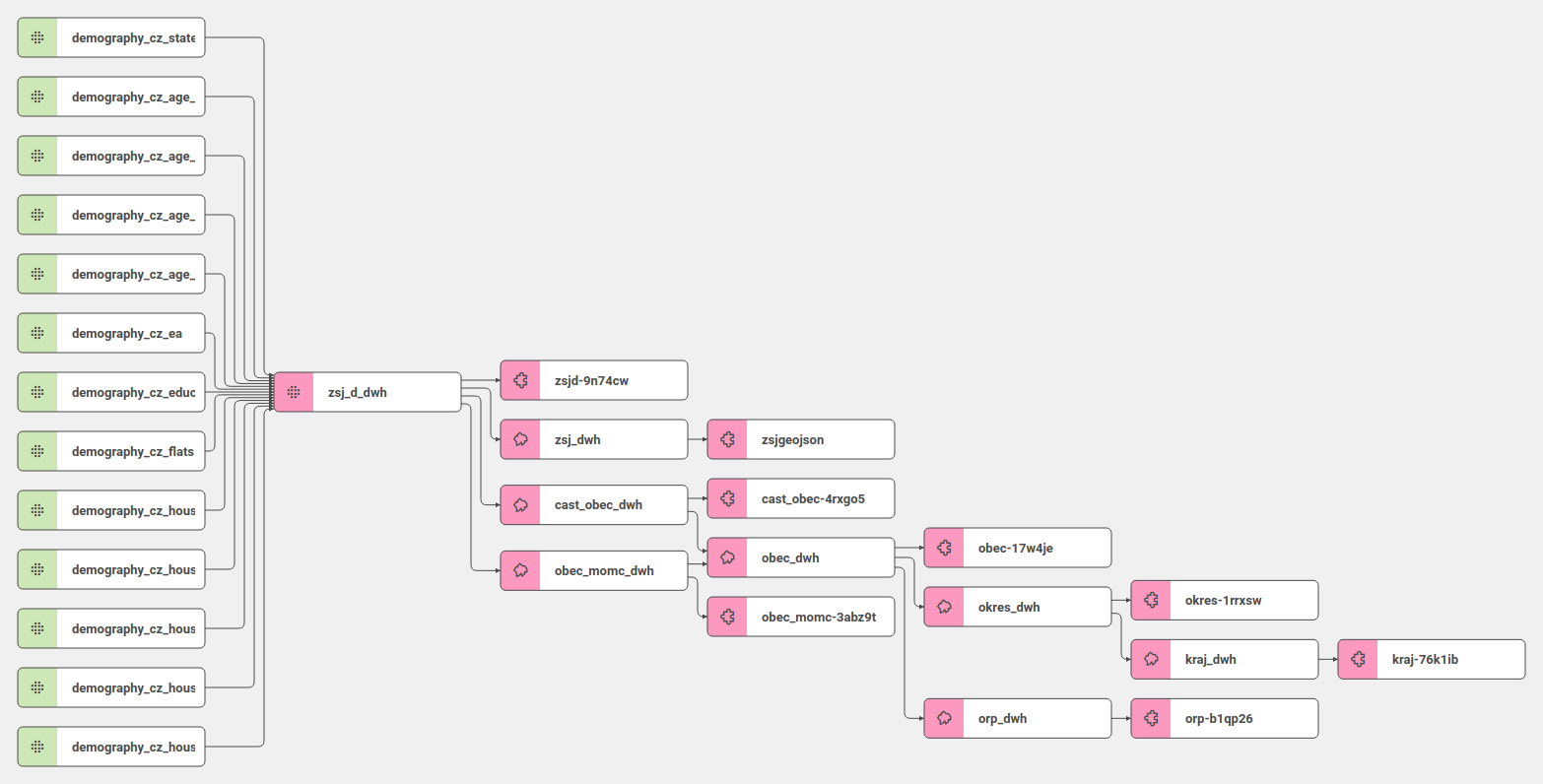
zsj_d_dwh - Neighborhoods (Základní sídelní jednotky)
cast_obec_dwh - Aministrative districts (Části obcí)
obec_momc_dwh - Municipality and City districts (Obce a městské části)
obec_dwh - Municipalities (Obce)
orp_dwh - Municipalities with extended competences (Obce s rozšířenou působností)
okres_dwh - Districts (Okresy)
kraj_dwh - Counties (Kraje)
Data model:
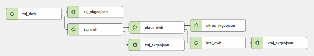
can-dim-adm-units-sk
Administrative units of Slovakia
Administrative units hierarchy of the Slovak Republic.
- Project ID: h3aytnzloh7tzpko
- Link: https://secure.clevermaps.io/#/h3aytnzloh7tzpko/project
Every hierarchy unit has its own table:
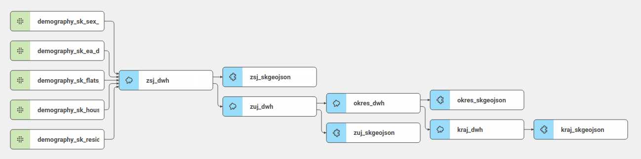
zsj_dwh - Neighborhood (Základné sídelné jednotky)
zuj_dwh - Municipalities (Základné územné jednotky)
okres_dwh - Districts (Okresy)
kraj_dwh - Counties (Kraje)
Data model:
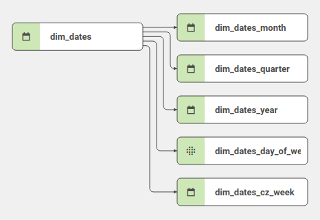
can-dim-dates
Dates dimension
Dimension contains all dates from 2010-01-01 to 2025-12-31.
- Project ID: tbagvahj2yvva9cx
- Link: https://secure.clevermaps.io/#/tbagvahj2yvva9cx/project
- Dates are divided to Days of week, Weeks, Months, Quarters and Years.
- Project has no views.
Data model:
Import guide
There are few things to note when importing a can-dim-dates dimension into your project:
To match the property of your fact dataset (orders in this case) with the primaryKey of dim_dates, you have to use the date type and set the foreignKey to point to the dim_dates table.
    ...
{
    "filterable": true,
    "name": "order_date",
    "title": "Order date",
    "column": "order_date",
    "type": "date",
    "foreignKey": "dim_dates"
},
    ...
The primaryKey of dim_dates table is in the ISO 8601 (YYYY-MM-DD) format.
We accept 4 possible date formats. These recognized formats are automatically converted to the YYYY-MM-DD format during the import, to match the dim_dates.date_iso property.
| Example | Format | Note |
|---|---|---|
| 2013-10-31 | YYYY-MM-DD | ISO 8601, preferred |
| 10/31/2013 | MM/DD/YYYY | |
| 31-Oct-13 | DD-MON-YY | case insensitive |
| 31/Oct/2013 | DD/MON/YYYY | case insensitive |
And to enable the date picker, you have to add the globalDate filter to your view. Here is an excerpt from the view, showing the correct settings of filterGroup.
   ...
"filterGroup": [
    {
        "type": "globalDate",
        "property": "orders.order_date"
    }
]
   ...
Please note that when you have 2 distinct fact tables containing 2 properties you would like to filter using can-dim-dates (e.g. order date & shop opening date), you have to import the dimension twice. Due to the nature of import command, you have to specify a prefix for the second import like this:
import --project tbagvahj2yvva9cx --prefix "shops_"
can-dim-demography-cz-en
Demography of the Czech Republic
- Basic demographic attributes of Czech Republic - citizens, households, houses, flats.
- Project ID: cn0fv61t751c6elt
- Link: https://secure.clevermaps.io/#/cn0fv61t751c6elt/project
- Demography project contains own Demography tables and imported tables from Administrative units of the Czech Republic
- Data model:
can-dim-demography-sk
Demography of Slovakia
- Basic demographic attributes of the Slovak Republic - citizens, households, houses, flats.
- Project ID: vommuqm52187ysyb
- Link: https://secure.clevermaps.io/#/vommuqm52187ysyb/project
- Demography project contains own Demography tables and imported tables from Administrative units of Slovakia
- Demography project contains 6 indicators and indicator drills:
- Residents and categories by age
- Residents and categories by sex
- Economically active population and categories by sector
- Households
- Houses
- Flats and categories by house type
- Data of those 6 indicators comes from 5 tables (you can see in data model)
- Data model:
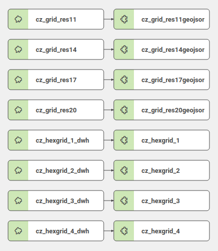
can-dim-grid-cz
Grid of Czech Republic
Project divides the area of Czech Republic to polygons or hexapolygons.
- Project ID: k51ytmasn2u6hpyt
- Link: https://secure.clevermaps.io/#/k51ytmasn2u6hpyt/project
- There are 4 resolution types of grid by size.
Data model: